


![sw[1]](https://iberiana2.files.wordpress.com/2013/04/sw1.jpg)
• რუკები – Maps
♥ Georgia-საქართველო
Portolan chart & Georgia
საზღვაო რუკები და საქართველო
1321 Petrus veescone, Bibliotheca Apostolica, Vatican
c.1320-21 undated but signed by Vesconti, for Marino Sanudo’s Liber secretorum, mappa mundi plus atlas of five sheets (partially missing), held (Pal.Lat.1362A) by the Bibliotheca Apostolica in Vatican City (2. Black sea, 3. Aegean, 4. Palestine & east Medit. 5. Adriatic and North Africa, 6. west Medit and north Atlantic)
– карты, разрабатывавшиеся для нужд мореплавателей. На них довольно точно показана береговая линия с упоминанием многочисленных прибрежных объектов (поселки, гавани, реки, скалы и т.д.). А остальная территория составителей карт не интересовала. К сожалению, условные значки практически не применялись, поэтому отличить название селения от названия местности можно было только по памяти. Флаги с гербами отмечают принадлежность важнейших торговых пунктов. Владения Византии (слева внизу) отмечены крестом с четырьмя буквами “В”; Трапезунда – двухглавым орлом (да-да, тем самым!). Ближайший к нашим местам флаг показан в Танне (теперь Азов) и, видимо, представляет тамгу татарского хана. В книге имеется еще черно-белый фрагмент этой же карты с западной частью Черного моря.
1330(/5). Angelino Dalorto. Biblioteca Príncipe Corsini, Florencia.
1339. Angelino Dulcert. Biblioteca Nacional, París.

1339-1350. Angelino Dalorto/Dulcert . The British Library
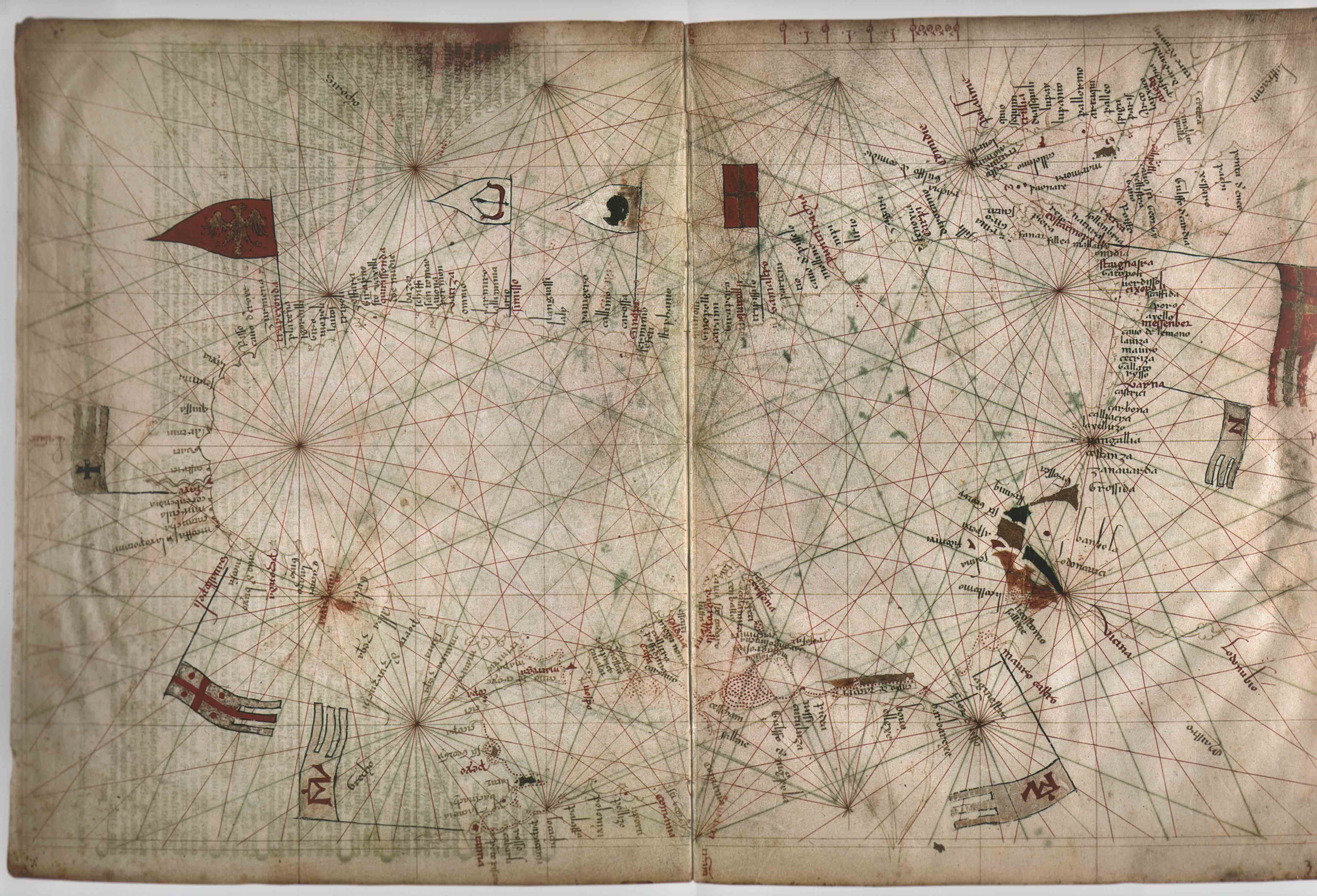
1367. Domenico y Francesco Pizzigani. Biblioteca Palatina, Parma.
Является частью большой карты братьев Франциска и Доминика Пицигани (венецианские картографы), репродуктирована в книге “Перипл Каспийского моря по картам XIV столетия, Ф.Бруна. Одесса, 1872.”
На карте обозначены западногрузинские провинции Zequa (Джикети), Auogaxia (Абхазия) и Suania (Сванети), локализованные в горах.
Вдоль Черного моря зафиксированы почти те же топонимы, что и на карте Весконте.
Так, севернее Фазиса (faxio), т.е. р. Риони находятся:
1. Hapotano- (греч. Hippotanos?) – букв. “Река Лошади”, т.е. “Цхенис цкали”.
2. Negapotano – тот же laxo potamo (см. карту 1318 г ), т.е. р.Ингури.
3. Corbondia – Гурбедия//Агубедия
4. Tamasa – Сатамашо; грузинский топоним, который после апсуизации принял форму “Тамыш”.
5. Goro -р Кодори.
6. Cicara – от мегрельского рцкапа, т.е. спаривание, соединение см. Венецианскую карту XIII века, прим.8.
7. Scouastolpoli (Севастополь) = Сухуми//Цхуми Примечательно, что по карте Сухуми находится в Суании//Сванети
8.Flum. nicola (р. Никопсия) – р. Анакопиис цкали древнегрузинских источников.
9. Cavo de bux – “Самшитовая гавань” См. Венецианскую карту XIII в.
10. Peconda (Бичвинта) – грузинская форма русской Пицунды и греч. Питиус.
11. Auogazia (Абхазия) – локализована в горах. Как сказано в историографии, этимология мегрельская – “находящаяся в горах”, “горская” (см. Венецианскую карту).
12-14. giro; Cacary, Ayazo//Laiazo – см. Венецианскую карту и карту Весконте.
15. Casto – (“Побережье” – по-лат.); нынешняя Хоста.
16 Cuba – см. Венецианскую карту.
17 Cequa – Джиха//Джигети.
18 Albacaqia – “Белая крепость” (см. Карту Весконте).
19. Porto de Susaco – Гавань Цурцухи
20. Mancaqua – “Черная Джиха” (см. Карту Весконте). 21 Manlaco – “Черное озеро”.

1380 Guillelmus Soleri, Bibliothèque nationale de France
Карта хранится в отделе картографии Парижской национальной библиотеки (Paris, B.N. Cartes et Plans, Res Ge В 1131); она охватывает и бассейн Черного моря. К северу от Сухуми (Sauastopoli) в горах реет флаг с изображением руки (ладони). Современные апсуйские сепаратисты на его основе создали свой нынешний флаг. На самом же деле этот символ (рука) является чисто грузинским и никакого отношения с апсуйцами (тогда еще не проживавшим на территории современной Абхазии) не имеет. В Грузии сохранились многочисленные эпиграфические памятники, особенно стеллы с изображением руки//хели (на груз). Термином “хели” (рука) в средневековой Грузии прежде всего обозначалась царская “власть” (на груз. язык “власть” переводится ках “хелисуплеба” = хели+уплеба; букв. полномочие руки), а также магия, профессия, дипломатика
Можно назвать несколько стелл с изображением руки – символа царской власти: Стелла Лаша Георгий из с. Гуния – кала (1202-1207 гг.); Тамар из с.Чхиквта (1195-1207 гг.); царицы Тамар и Лаша Георгий из с.Пртена<1189-1202); царицы Русудан из с. Архоти (1222-1245 гг.); царицы Русудан из с.Диди Тонети (1222-1245 гг.); царя Давида из с.Сагамо (1259-1270 гг.). Подобные стеллы являлись юридическими документами – актами, подтверждающими царское право на владение той или иной землей (см. подробно Г.К. Отхмезури. Грузинские лапидарные надписи рубежа XII-XIII вв. как исторический источник. Тб., 1981, с. 7-37, на груз.яз; с.120-122.
Резюме на русск.яз.). флаг с изображением руки также указывает на право определенного владетеля на эту землю. Документы XIV в. (№№64, 65 и др.) однозначно указывают, что Сухуми принадлежала Грузии. Ал-Мухибби (не позже 1384 г.) пишет: "Грузины имеют двух царей – царь Давид, который правит Тифлисом и Дадиани – царь, правящий Сухумом и Абхазом" (док.№67). Таким образом, рука (ладонь) на флаге, развевавшемся севернее от Сухуми, может быть лишь символом власти грузинского (мегрельского) владетеля Дадиани. Никто другой не владел этими землями вплоть до XVII в.Карта Солери богата различными декоративными украшениями, некоторые флаги (но не над Сухуми) позолочены или окрашены блестящими красками.
К северу от Фазиса (Риони) обозначены:
1. hipotamo(Hippotamo- греч.) – р. Цхенисцкали 2. Negapotamo – Большая река//Ингури. 3. Corebendia – Гурбедия//Агубедия. 4. Tamasa – Сатамашо//Тамышь. 5. Goto – “Кодори”. 6. Cica (Цхаба) – Тхубуни (или Дранда). 7. Sauastopoli – Сухуми. 8. Flum. nicola – p. Анакопиисцкали. 9. Cavo de Bux – Самшитовая гавань (Бзыбь). 10. Pezonda – Пицунда//Бичвинта. 11. Giro – Пицундский мыс (“круг”). 12. [Santa] Sofia – Санта София – генуэзская колония. 13. Cacari – Гагра. 14. Lauazo – “Камень-дерево”. 15. Sichia -Джихиа. 16. Costo-Хоста. 17. Cuba – см. карту Весконте. . 18. Abazachia – Абхазия. 19. Porto de Susacho – Гавань Цурцухи. 20. Май Zichia – Черная Джиха//Джикети.***
%2004.jpg)
1439. Gabriel Vallseca. Museo Marítimo, Barcelona.
Valseca’s most famous map is the portolan of 1439, particularly for incorporating the very recent discoveries of the captains of the Portuguese Prince Henry the Navigator. Its depiction of the Atlantic Ocean stretches from Scandinavia down to the Rio de Oro and including the Atlantic islands of the Azores, Madeira and Canaries, as well as the imaginary islands of Thule, Brazil and Mam.The most notable is the depiction of the islands of the Azores (officially discovered in 1431 by Henry’s captain Gonçalo Velho Cabral), which although incorrectly spaced, are accurately depicted for the first time as strung out from southeast to northwest.According to a marginal note, the 1439 map was once owned by Amerigo Vespucci, who paid 80 gold ducats for it. (Questa ampia pella di geographia fue pagata da Amerigo Vespucci – LXXX ducati di oro di marco). It is conjectured Vespucci might have acquired it in Florence in the late 15th C. and taken it to the New World with him. At some point it came into the hands of the Majorcan Counts of Montenegro. The map suffered an accident in 1869, when the Count of Montenegro was in the process of showing it to his visitors, Frédéric Chopin and George Sand. A carelessly-placed inkwell tipped onto the map, causing irreparable blots and marring the legibility of some of the labels, most crucially that pertaining to the discovery of the Azores. The current note reads as follows:Aquestes isles foram trobades p diego de ??? pelot del rey de portugal an lay MCCCCXX?II (Transl. “These islands were found by Diego de ? pilot of the King of Portugal in the year 14??”)
***
1447. Gabriel Vallseca. Biblioteca Nacional, París.
Title : [Carte marine de la mer Méditerranée et de la mer Noire] / Gabriel Devallsecha la affeta en mallorcha an MCCCCXXXXVII..
Type : document cartographique,document cartographique manuscrit,image fixe
Language : Catalonian..Source : Bibliothèque nationale de France, département Cartes et plans, CPL GE C-4607 (RES)
***

1559. Diogo Homem.Biblioteeca Nacional, París.
Надпись – “Mengralia” (т.е. Мегрелия), а также грузинский флаг недалеко от Азовского моря и многие топонимы неопровержимо доказывают, что “за р.Кубанью находится Мингрелия” (док. №76).
К северу от Фазиса обозначены:
1. Lipotimo(Hippotamo) – р. Цхенисцкали. 2. Negapotimo (Meganotamo) – р. Ингури. 3. Coro bendy (Corbedua) – Гурбедия (Агубедия). 4. Tamansa – Сатамашо//Тамышь. 5. Goto – р.Кодори. 6. Zicaba – Цхаба//Тхубуни (или Дранда). 7. Malfitan – Мальфитан. 8. P.Megrelo – Порто Мегрело обозначено на картах Бенинказа (1480 г.) и Фредруче (1497 г.). Одновременное обозначение на карте XVI в. “Мальфитан” и “Порто Мегрело” ставит под сомнение утверждение о том, что первое (Мальфитан) является более поздней формой названия Порто Мегрело. На карте хорошо видно (см. еще карту Майоло), что они находятся в разных местах и подменить друг друга не могли. Возможно, “Порто Менгрело” в определенное время потеряло свое значение (и оно не обозначалось на всех картах), уступив его порту Мальфитану: 9. Sauastonoli – Сухуми. 10. C.Sauastopoli – Сухумский мыс. 11. Flume de cofia – Анакопиисцкали. 12. C.Buxio – Самшитовая гавань//Бзыбь. 13. Peconda – Бичвинта. 14. giro – “круг” (Пицундский мыс). 15. Cacari – Гагра. 16. Aiaso – см. Laiazo на карте Весконте. 17. Costo – Хоста. 18. C.decuba – Мыс Кубы. См. еще на карте Весконте. 19-20 Sana; Alba Zichia – см. карту Весконте. 21. Р[орто] decucacho. 22. Alba Zichea – ошибочно повторено и перечеркнуто самим автором. 23. F.Lodar. 24. MauraZech – “Черная Джиха’7/Джикети. 25. Corcca – “урчание” (?). 26. Mauro Laco – “Черное озеро”.***

დატოვე კომენტარი